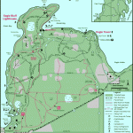
PATT1SON STATE PARK MAP WISCONSIN
Located in northwestern Wisconsin, Pattison State Park has a 27-acre lake, a river with a deep gorge, and a couple of lovely waterfalls, including 165-foot Big Manitou Falls, highest in the state. Deer, bear, moose, and coyote are among the wildlife here.
Activities: There are about six miles of hiking trails in the park. Cross-country skiing is available in winter. Fishing is possible along the river or at the lake. Hunting is prohibited.
Camping Regulations: Backpack camping is allowed at three areas near the Black River, about 1.6 miles via trail from the parking area, and not far from 30-foot Little Manitou Falls.
Primitive camping is restricted to these sites. A fee is charged for camping each night, and sites may be reserved in advance. Campfires are permitted in the fire rings provided.
For Further Information: Pattison State Park, Route 2, Box 435, Superior, WI 54880; (715)399-8073.
PATT1SON STATE PARK MAP WISCONSIN Photo Gallery
Maybe You Like Them Too
- Explore Góra Kalwaria, Poland with this detailed map
- Explore Gumdag, Turkmenistan with this detailed map
- Explore Telfes im Stubai, Austria with this detailed map
- Explore Langenselbold, Germany with this detailed map
- Explore Krotoszyn, Poland with this detailed map

