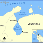
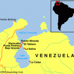
LAKE MARACAIBO BRIDGE MAP
For the first time, concrete was used for both pylons and deck in a cable-stayed bridge.
In the fifteenth century, when the Spanish conquistador Alonso de Ojeda saw the picturesque thatched huts on stilts over Lake Maracaibo, he was reminded of Venice, and named the place accordingly: Venezuela. Today thousands of lanky oil derricks stand in the lake, as they have since 1914, when oil was discovered there. The discovery transformed Venezuela’s economythe nation remains one of OPEC’s largest producersand led to the development of large-scale public works in the 1950s to improve the country’s infrastructure.
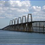
One such project, the Lake Maracaibo Bridge, also known as the Puente General Rafael Urdaneta, after the Maracaibo-born hero of the country’s struggle for independence from Spain, was completed in 1962. A significant engineering achievements of the twentieth century, the innovative bridge was the first multispan cable-stayed bridge and the first prestressed concrete bridge. It stretches 5.4 miles (8.7 kilometers) across Lake Maracaibo’s narrow northern neck, providing the first direct surface link between Maracaibo and the rest of Venezuela.
LAKE MARACAIBO BRIDGE MAP Photo Gallery
It is a work of transcendental economic importance.
Eleven of the twelve submissions to the government’s international request for proposals for the vast lake crossing were designs in structural steel. The exception was the reinforced-concrete cable-stayed design by the brilliant Italian engineer and teacher Riccardo Morandi (1902-1989). Like his peers Pier Luigi Nervi, Robert Maillart, and Felix Candela, Morandi transformed reinforced concrete from a purely structural medium into an instrument of architectural expression. The powerful, square-shouldered profile that Morandi developed at Lake Maracaibo would prove a signature design, one that he would vary in his future cable-stayed bridges, notably the Polcevera Viaduct (1968) in Italy and the Wadi Kuf Bridge (1972) in Libya.
Morandi’s design was chosen for economic and political reasons as well as for aesthetic ones. Less expensive than steel, concrete would require less maintenance in the corrosive tropical environment. Moreover, the local labor force would benefit from the experience of working in prestressed concrete, a plus for a country that was rapidly expanding in the wake of the 1958 overthrow of its military dictatorship.
The bridge consists of 135 spans that gradually rise along an eastern viaduct to meet five central cable-stayed spans and then descend to the western shore. Each central span is 771 feet (235 meters) long, with a 150-foot (46-meter) clearance for maritime traffic. The A-shaped concrete pylons of the five central spans are 303 feet (92 meters) tall. To reduce costs, the design employed standardized units whenever possible.
In the first generation of cable-stayed designs, a small number of massive cable stays were used to support the roadway, requiring large anchorages and heavy box girder decks. Niels Gimsing and Christos Georgakis point out in Cable Supported Bridges: Concept and Design that as cable-stayed systems developed, the number of stays was increased to support the deck, which could then be made lighter and more slender. As they approach the central section of the bridge, the side spans become taller and wider, and the piers change from a V shape to the pinched H shape seen here. To relieve congestion, a second lake crossing is now in the works. In 2012, construction began on the Nigale Bridge, a 7.3-mile (11.7-kilometer)-long cable-stayed span designed by COWI that will carry two railway tracks and four vehicular lanes. Brazilian contractor Odebrecht, one of the largest civil engineering companies, is building it. Oil spills in the lake have decreased commercial fishing, once a vibrant part of the local economy.
Maybe You Like Them Too
- Explore Doncaster, United Kingdom with this detailed map
- Explore Arroyito, Argentina with this Detailed Map
- Explore Belin, Romania with this detailed map
- Explore Almudévar, Spain with this detailed map
- Explore Aguarón, Spain with this detailed map


