Counties: Aust-Agder fylke, Vest-Agder fylke.
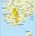
The Setesdal (or Saeterdal), the valley of the Otteri (Otra), extends almost due N for a distance of 230 km (140 miles) from Kristiansand, on the S coast of Norway, forming an important traffic route to Bergen and the Hardangerfjord. It has much to offerthe visitor, with its beautiful scenery and a population still bound by old customs and traditions.
Motell, 56 Hornnes Sommerpensjonat, S of town, 100 b.) has boatyards, woodworking industry and felspar quarries. At Evjemoen, to the S, was a nickel works (closed 1 946) using ore from Fiat. The minerals of the region (amazonite, beryl, aquamarine, etc.) will be of interest to geologists.
Bygtandsfjord (alt. 207 m (680 ft); Revsnes Turisthotell, 84 Solvik Turist-heim, 26 b.), on the southern shore of the lake ofthe same name, through which the River Otra flows, is a winter sports resort (chair-lift, ski trails). It was formerly the terminus of the Setesdal railway (closed 1 962). Road 1 2 follows the E side ofthe Bygtandsfjord, with theArdalsfjelt (760 m- 2494 ft) rising above the fjord on the right. Sections of the road have been blasted from the rock.
Ardal has an interesting church (1827), with a runic stone in the churchyard. 300 m (300yds) S ofthechurch isa 900-year-old oak-tree. On a hill to the NE is the Landeskogen home for the mentally handicapped.
Bygland (Solvik Turistheim, 26 b.), at the foot of Lysheia (845 m 2772 ft), has a church (1838); in the churchyard are prehistoric cult stones. There are several old burial mounds in the surrounding area. Good fishing in the fjord.
The road crosses the fjord on the Stores-traum bridge and runs along its western shore. To the left is the Reiarsfoss. At the N end of the fjord are old store-rooms built on piles (stabbur). Following the course of the Otra, the road runs past the Rustfjell (1 070 m 3511 ft) on the left.
The road continues through magnificent scenery to Helle, an old-established silversmithing town.
At Nomeland, a road branches off on the left to the Brokke power station (beautiful view of the valley). Nearby is Syvartun, an old wooden house which contains a collection of silversmiths’ work.
Soon afterward, the Hallandsfoss, a 1 5 m (50 ft) high waterfall with several deep ”glacier mills (cavities gouged out by swirling melt-water), is passed on the left. Beyond this, in a wider part ofthe valley, is the main town in the Setesdal, Valle (alt. 307 m (1 007 ft); Valle Motell, 32 Valle Sommer Motell, 72 camp site, old houses, church of 1 844). 9 km (6 miles) beyond Valle is the farm of Flateland, where a side road (2 km 14 miles) leads to the Setesdal Museum (old wooden houses).
Road 12 continues high above the Otra, running through a gorge to Bykle, a short distance E ofthe Bossvatn.
Bykle (alt. 549 m (1 801 ft); Bykle Hotell, 55 b.) is an old village steeped in the peasant traditions of the valley. The 1 3thc. church has a fine 1 6th c. interior. N of the church is the Huldreheim Museum (1 6th c. wooden houses). A little E of the village is the Sarvsfoss, the highest waterfall in the Setesdal (30 m-100ft). A number of marked footpaths lead from Bykle into the hilly surrounding country.
N of Bykle, the valley becomes flatter and the landscape more mountainous in character. The road crosses the Otra again on the Berdal bridge and then skirts the E side of the Hartevatn.
Hovden (alt. 740 m (2428 ft); Hovden Hoyfjellshotell, 170 Triangel Sportell, 44 b.), beautifully set above the outflow of the Otra into the Hartevatn, is the primary winter sports and climbing resort of the Setesdal, with chair-lifts.
Beyond Hovden, the road runs past the Lislevatn, Breivatn and Sessvatn, and reaches its highest point (91 7 m 3009 ft); it then descends through Haukelig-rend and from there on the Haukeli Road (266) to Haugesund.
Setesdal Norway Map Photo Gallery
Maybe You Like Them Too
- The Best Cities To Visit in The World
- World’s 10 Best Places To Visit
- Coolest Countries in the World to Visit
- Travel to Santorini, Greece
- Map of Barbados – Holiday in Barbados

