Province: Hainan
Area: 1878sq.km/725sq. miles
Population: 70,000 (conurbation 420,000)
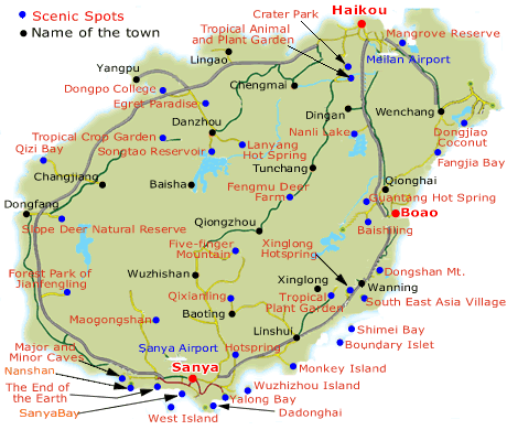
Sanya, China’s southern-most city, lies at 109°29’E and 18°10’N on the southern tip of the Hainan Island. It has connections by air with the provincial capital Haikou and Canton.
On the clean white beaches of Sanya bathing is possible throughout the year. Extensive construction work on new hotels and holiday villages is in progress.
Stag Cape is the southern tip of Hainan island 6km/4 miles south of Sanya. Its shape is reminiscent of a deer with its head facing backwards. The rocky beach is rich in coral-reefs.
The over 3m/10ft deep Cave of the Fallen Paintbrush lies 10km/6 miles to the west ofthe city on the south-western slope of a mountain. Here can be seen a stalactite which looks like a giant paint brush. Underneath a bulging stone catches the lime drops which fall from its roof. Before the local residents send their children to school for the first time they put them to a little test in this grotto: If the child succeeds in catching a falling drop in the palm of his hand then he will achieve good marks and a successful journey through life; otherwise other possibilities must be explored.
Sanya: “End ofthe World” Cape The Cape at the End of the World, some 24km/15 miles to the west of Sanya, Cape at the was once renowned as “the most remote spot in the world”. End of the World On the rocks which lie around the cape numerous ideograms can be (Tianyahaijiao) identified; they were carved in 1733 by the provincial governor and other civil servants of the time. The inscriptions repeatedly concern the remote geography of this stretch of land: “Absolute End of the World”, “Beginning of the Sea”, “Pillars of the Southern Firmament”, etc.
Hainan Map Photo Gallery
Maybe You Like Them Too
- The Best Cities To Visit in The World
- World’s 10 Best Places To Visit
- Coolest Countries in the World to Visit
- Travel to Santorini, Greece
- Map of Barbados – Holiday in Barbados