PIGEON LAKE MAP EDMONTON
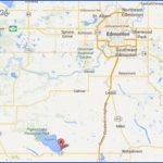
Directions: Exit Edmonton on Hwy 2 south. Take exit 482B to reach Hwy 13 (west). Distance: 88 km, or about 1 hour and 8 minutes, from Edmonton.
Info: www.pigeonlake.com.
A large, shallow lake, Pigeon Lake may have been named for the vast flocks of passenger pigeons once common here. The lake’s Cree name is Hmi-hmoomeaning Woodpecker Lake. For hundreds of years, Aboriginal people used a trail on Pigeon Lake’s northwest shore and took advantage of an artesian well along the path.
Formerly of Liverpool, England, Methodist missionary Reverend Robert Rundle travelled through the Pigeon Lake area in 1845. He initially came to Edmonton in 1840 to serve the Aboriginal people and work as company chaplain at Edmonton Housethe original Fort Edmontonlocated where the Sturgeon River flows into the North Saskatchewan River, just north of modern-day Fort Saskatchewan. Rundle found the Aboriginal people interacted very differently when he met them at their own camps rather than at Fort Edmonton, and he requested permission to establish a mission outside the Hudson’s Bay Company fort.
His request was approved, and Rundle chose to locate the new mission on the northwestern shore of Pigeon Lake because of its abundant supply of fish and the clean water that continually flowed from the artesian well. He knew the land was fertile, for he had tested it and found it suitable for agriculture. Rundle considered it an ideal place to conduct missionary work and to work toward his dream of helping the Aboriginal people grow their own provisions. He established the Rundle Mission in 1847a time when food shortages were an increasing concern. The original mission consisted of a few log buildings clustered around the well. Rundle introduced syllabics to the Cree who came to the mission, which enabled them to read and write in their own language for the first time. Nakoda, Cree, and missionaries continued to meet here for nearly 50 years. You can see a national historic monument that was dedicated to Reverend Robert Rundle in 1967 and visit the Benjamin and Margaret Sinclair Alberta Historic Site, where the stories of residents and visitors are told along the self-guiding interpretive trail. Access the beach across the road from the mission or visit the public Mission Beach half a kilometre down the road.
Pigeon Lake’s western shore is also historically significant. It was home to a Hudson’s Bay Company trading post that closed only seven years after its 1868 opening. Commercial fishing, logging, and farming helped settlers get by in the early 1900s, but today Pigeon Lake is known for its recreational appeal.
In addition to restaurants and a number of other services, the Village at Pigeon Lake offers a charming boardwalk of country shops to wander through, including an irresistible bakery at the Village Market. Upon entering the store, look for the artwork display showing local homesteaders, as well as the hand-hewn replica of the original Crystal Springs Store. For more information, visit www.villageatpigeonlake.com. Community events include tailgate sales, annual dogsled races, and an ice-golf tournament at Mulhurst Bay.
In addition to trails within the provincial park, Pigeon Lake has walking paths through an hectare nature reserve adjacent to Rundle Mission. You can stop for a picnic on the hill overlooking Pigeon Lake, where you will find an outdoor toilet and the always-open Telfordville Church. There is a small group shelter and firepits on the east side of Memorial Lodge, which can be used by the public when not booked by a group. The six kilometres of ski trails at Rundle Mission are groomed.
Mulhurst Bay on the north side of Pigeon Lake has a small beach area and boat launch. You can reach it on Highway 771 northa 10-minute drive from the Village at Pigeon Lake.
Ma-Me-O Beach
Location: At the southeast end of Pigeon Lake on Hwy 13A.
Info: 780-586-2494; www.pigeonlake.com.
The Summer Village of Ma-Me-O Beach is located on Pigeon Lake’s south end and takes its name from the Cree word ma-me-o, meaning white pigeon. Ma-Me-O boasts a sandy beach with shallow water that is ideal for young children. Amenities include changing and toilet facilities, picnic shelters, docks, boat launches, and playgrounds, as well as a concession. The village has a tennis court, along with a town hall where bingos, flea markets, and family dances are held.
PIGEON LAKE MAP EDMONTON Photo Gallery
Maybe You Like Them Too
- Explore East Lindfield, Australia with this detailed map
- Explore Bonferraro, Italy with this detailed map
- Explore Doncaster, United Kingdom with this detailed map
- Explore Arroyito, Argentina with this Detailed Map
- Explore Belin, Romania with this detailed map

