Hiking Distance: 4-Mile Loop
Hiking Time: 2 Hours
Configuration: Loop
Elevation Gain: 1,000 Feet
Difficulty: Moderate To Somewhat Strenuous
Exposure: Mostly Exposed
Dogs: Allowed
Maps: U.S.G.S. Thousand Oaks N.P.S. Cheeseboro/Palo Comado Canyons
China Flat, A Newer Addition To The Cheeseboro/Palo Comado Canyons Site, Is A High, Oak-Dotted Grassland Meadow With Sedimentary Rock Outcroppings.
Cheeseboro/Palo Comado Canyons Map Photo Gallery
The Flat Is Perched On The West Side Of Palo Comado Canyon Beneath The Shadows Of Simi Peak, The Highest Peak In The Simi Hills. The China Flat Trail Is A Steep Hike With Awesome, Panoramic Views Of Simi Valley, Oak Park, Agoura Hills, And Westlake Village. Connector Trails Link China Flat To The Upper Reaches Of Palo Comado And Cheeseboro Canyons (Hikes 137¬140).
To The Trailhead
From Ventura Freeway/Highway 101 In Westlake Village, Exit On Lindero Canyon Road. Drive 4 Miles North And Park On Lindero Canyon Road By The China Flat Trailhead On The Left. It Is Located Between King James Court And Wembly Avenue.
The Hike
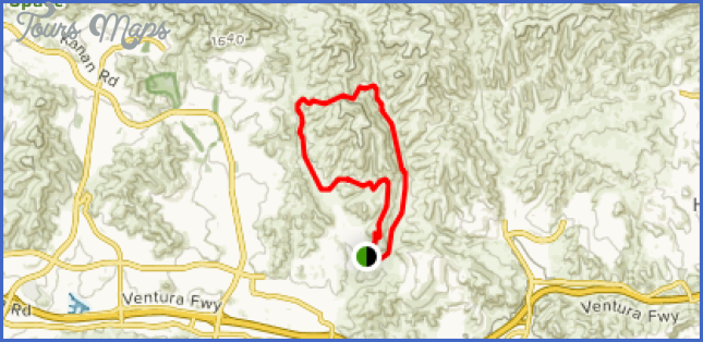
Hike North Past The Trailhead Sign Towards The Mountains. Climb The Short, Steep Hill To Where A Trail From King James Court Merges With The Main Trail. Continue Around The East Side Of A Large Sandstone Outcropping. The Trail Levels Out And Heads East, Following The Contour Of The Mountain Base, To An Unsigned Junction. Take The Left Fork North, Heading Uphill Towards The Ridge. Once Over The Ridge, The Trail Meets Another Unsigned Junction. Take The Left Fork And Head West, With Views Overlooking The Canyon. Proceed Uphill Along The Ridgeline To A Flat Area And Trail Junction. The Right Fork Leads Back Towards Palo Comado And Cheeseboro Canyons. Take The Left Fork And Descend To Another Junction. Again, Take The Left Fork, Winding Downhill To A Gate At King James Court. Leave The Trail And Walk One Block On The Sidewalk To Lindero Canyon Road. The Trailhead Is To The Left. I
Cheeseboro/Palo Comado Canyons
Hiking Distance: 5-Mile Loop
Hiking Time: 2.5 Hours
Configuration: Loop
Elevation Gain: 800 Feet
Difficulty: Moderate To Slightly Strenuous
Exposure: A Mix Of Shaded Canyon And Open Hillsides
Dogs: Allowed
Maps: U.S.G.S. Thousand Oaks And Calabasas N.P.S. Cheeseboro/Palo Comado Canyons
Palo Comado And Cheeseboro Canyons, In The Simi Hills Near Agoura Hills, Is A Wildlife Corridor Connecting The Santa Monica Mountains With The Santa Susana Mountains. This North-South Corridor Allows Animals To Move Between The Two Ranges. This Hike Makes A Loop Around The Undeveloped Upper Ends Of Palo Comado Canyon And Cheeseboro Canyon. The Trail Leads Through Meadows And Parallels The Canyon Streams. After Crossing Over Into Cheeseboro Canyon, The Hike Follows The Canyon Floor On An Old Ranch Road Through Grasslands With Groves Of Stately Valley Oaks And Twisted Coast Live Oaks.
From Ventura Freeway/Highway 101 In Agoura Hills, Exit On Kanan Road. Head North 2.2 Miles To Sunnycrest Drive And Turn Right. Continue 0.8 Miles To The “Public Open Space” Sign On The Right. Park Along The Curb.
The Hike
From The Trailhead, Hike East Past The Gate And Up A Short Hill On The Sunnycrest Connector Trail. As You Top The Hill, The Trail Descends Into Palo Comado Canyon. Cross The Stream At The Canyon Floor To A Junction With The Palo Comado Canyon Trail, An Old Ranch Road. Head Left Up The Canyon Through Rolling Grasslands With Sycamore And Oak Groves. At One Mile The Trail Begins To Climb Out Of The Canyon, Winding Along The Contours Of The Mountain. Near The Head Of The Canyon, The Palo Comado Canyon Trail Curves Left, Heading To China Flat (Hike 136). There Is An Unmarked But Distinct Path Leading Sharply To The Right At The Beginning Of This Curve The Old Sheep Corral Trail. Take This Path Uphill To A Couple Of Ridges That Overlook Cheeseboro Canyon. Descend Into The Canyon A Short Distance To The Corral And A Junction At Shepherds’ Flat. Straight Ahead The Trail Climbs Up To Cheeseboro Ridge.
Take The Right Fork And Follow Cheeseboro Canyon Gently Downhill. At Sulphur Springs, Identified By Its Smell, Walk Beneath The White Sedimentary Cliffs Of The Baleen Wall On The East Canyon Wall. Continue Down Canyon Through Oak Groves To The Posted Ranch Center Connector Trail, 1.3 Miles Down The Canyon On The Right. Bear Right And Wind 1.1 Mile Up And Over The Chaparral Hillside From Cheeseboro Canyon Back To Palo Comado Canyon. Bear Right A Short Distance, Completing The Loop. Return To The Left On The Sunnycrest Connector Trail. I
Maybe You Like Them Too
- Top 10 Islands You Can Buy
- Top 10 Underrated Asian Cities 2023
- Top 10 Reasons Upsizing Will Be a Huge Travel Trend
- Top 10 Scuba Diving Destinations
- World’s 10 Best Places To Visit


