County: Troms fylke.
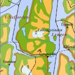
The Lyngenfjord is perhaps the most magnificent fjord in the IMord-land. It runs S for about 80 km (50 miles) from the Lyngstuva promontory (alt. 395 m 1296 ft) at the northern tip of the Lyngen peninsula, a snow-and-glacier-covered granite ridge which rises directly out of the sea between the Lyngenfjord and the Ullsfjord to the W.
The Lyngenfjord is reached from Troms© by taking E78, which runs SE to Nordkjosbotn and then turns E up the valley of the Nordkjoselv, through birch forest and between high hills, to Qver-gard. It then descends, with a view of the fjord ahead, to Oteren, at the S end of the Storfjord, the southern arm of the Lyngenfjord; to the SE is the jagged Mannfjell ridge (1533 m 5030 ft). At Oteren the road divides. One can continue up the main Road 6 along the W coast of Storfjord and by the W coast of Lyngenfjord to Lyngen and from Lyngseidet take the ferry (45 minutes) across to KSfjord. Alternatively one can take Road 78 from Oteren by the E coast of Storfjord and Lyngenfjord to Skibotn from which there is a very fine view of the W shores of the fjord with Pollfjell and beyond it the Jiekkevarre with its glaciers. At Odden, from which there is a good view of the glaciers at the N end of the far side of the fjord, the road turns SE and runs along the W side of the 20 km (12 mile) long Kafjord, enclosed between precipitous hills, to Kafjordbotn, at the head of the fjord.
The road now runs NW along the E side of the fjord to the village of Kafjord and then to Olderdal (Alskog Gjestgiveri, 40 b.). Kafjord was once the home of the very successful KSfjord mines which were founded and run by a British company, but known also for two other things: one, the very beautiful English church, quite unlike anything else erected in Norway and built by the company, but most especially for the fact that KSfjord is for Norwegians generally and most Scandinavians an almost sacred place. It was here, only just round the corner from the English church that the German ship Tirpitz, badly damaged, was spotted by three young Norwegian Resistance fighters who, at great danger to their lives, managed to get a radio message sent via Sweden to the British High Command. British aircraft made an unsuccessful attempt to attack her, but she was too well hidden. Midget submarines then made another heroic attack disabling her slightly, but she was able to limp to Tromso for proper repairs, where the R.A.F. made an all-out attack as a result of which she now lies bottom-up. Naturally, the Germans made reprisals. The three young men were found and taken to Tromso H.Q. by the Gestapo. One died there, the other two escaped during another attack; the older to Britain where had joined the allied forces; the younger, only 17, was hidden by the Resistance and now lives within a short distance of the spot where the Tirpitz lay hidden. The English church miraculously survived the bombings and is well worth a visit. From Olderfal there are two alternatives either continuing along the E side of the fjord, with magnificent views, in the direction of Rotsund, or by ferry (45 minutes) to Lyngseidet (Gjestgiveri, 22 b.) on the W side of the fjord. From Lyngseidet there are two good climbs each taking 4 hours Goalsevarre (1289 m 4229 ft) and Rornestind (1250 m 4101 ft). The road runs S to Furuflaten, under the Pollfjell (1280 m 4200 ft). From here it is a 4-5 hours’ climb up the Njallasvarre (1 530 m 5020 ft). Here is a magnificent view to the W of the glaciers on Jiekkevarre (1 833 m 6014 ft), one of the highest mountains in northern Norway, first climbed by Geoffrey Hastings in 1898. From here the main road to Tromso returns to Oteren.
SURROUNDINGS. Excursion into Finland (Kilpisjarvi and Saanatunturi). From the Olderbak-ken road junction, E78 runs SE to Kilpisjarvi. The first section of the road bears SW up the broad wooded valley ofthe Skibotnelv (good fishing), with the little (Dvrevann to right. It then comes to the winter customs post at Helligskogen, followed by the summer customs post, and soon afterward crosses the Norwegian-Finnish frontier. E78 now continues as the Finnish Road 21, with many ups and downs; ahead, to the right, is a view of Kilpisjarvi. In another 5 km (3 miles) the Finnish frontier post (customs) is reached.
Saanatunturi, on the shores of Kilpisjarvi
The road continues close to the shores of Kilpisjarvi (alt. 476 m (1 560 m), area 39 sq. km 1 5 sq. miles), which lies along the Swedish frontier (good fishing). At the N W tip of the lake (motorboat from hotel) is a round boundary stone marking the meeting-place of the three countries (Sweden, Norway and Finland); to the left is the characteristic outline of Saanatunturi. 3 km (2 miles) beyond the frontier post, on the left, is a climbers’ hostel, from which it is a 2-2 hours’ climb (sturdy footwear essential) to the summit of the distinctively shaped Saanatuntur (1024 m 3360 ft), the sacred mountain ofthe Lapps, from which there are panoramic views: to the N, the Malla National Park and, behind it, to the N and NW, the Norwegian mountains; tothe W, Sweden and to the S, Kilpisjarvi; to the E, the rolling forest-covered landscape of Finland and to the N, Finland’s highest mountain, Haltiatunturi (1324 m 4344 ft), a remote and inaccessible peak (a walk of 120 km (75 miles) from Kilpisjarvi: organised climbing parties, with guide).
5 km (3 miles) beyond the climbers’ hostel, to the right of the road, is Kilpisjarvi Turisthotel (70 b.), with a number of chalets. Road 21 continues SE alongside the Swedish frontier to Muonio and Tornio (267); side road from Muonio to Rovaniemi (229).
Lyngenfjord Norway Map Photo Gallery
Maybe You Like Them Too
- The Best Cities To Visit in The World
- World’s 10 Best Places To Visit
- Coolest Countries in the World to Visit
- Travel to Santorini, Greece
- Map of Barbados – Holiday in Barbados

