PACIFIC CREST TRAIL MAP WASHINGTON
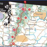
500 miles in Washington (2,638 miles total). Extending all the way from Canada to Mexico, with National Scenic Trail status, the spectacular Pacific Crest Trail is one of this country’s great long-distance wilderness trails.
In Washington the trail crosses the Cascades, passing through North Cascades National Park and Mount Rainier National Park. It also traverses several National Forests with a total of eight designated wilderness areas.
Much of this wild and often remote trail is at high elevations, and the route is likely to be snow-free only during the months of August and September. Difficulty ranges from easy to quite strenuous. Horses are allowed on the trail.
Camping Regulations: Camping is allowed just about anywhere in the National Forests along the way, except where posted otherwise. Permits are not currently required on these lands.
Backpackers are asked to use preexisting campsites whenever possible. Sites should be well off the trail, away from meadows and areas with vegetation, and at least 100 feet from water sources. Campfires are allowed but discouraged. It’s recommended that a stove be brought for cooking.
A wilderness permit is required for camping in the two National Parks. Either designated campsites should be used, or sites must be at least one-quarter mile from the trail (Mount Rainier National Park) or one-half mile from the trail (North
Cascades National Park). Campfires are allowed at designated sites in North Cascades, and prohibited in the other park.
Trail Information: Pacific Crest Trail Conference, 365 West 29th Avenue, Eugene, OR 97405.
PACIFIC CREST TRAIL MAP WASHINGTON Photo Gallery
Maybe You Like Them Too
- Arnold A Town with a Heart
- The Best Cities To Visit in The World
- World’s 10 Best Places To Visit
- Map of New York City – New York City Guide And Statistics
- Map of San Francisco – San Francisco Map Free

