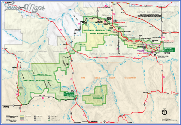
BADLANDS NATIONAL PARK MAP SOUTH DAKOTA
244,000 acres. Situated in southwest South Dakota, this National Park includes the largest area of prairie wilderness in the United States. It’s surrounded by the lands of Buffalo Gap National Grasslands and the Pine Ridge Indian Reservation.
The unusual landscape here includes barren badlands, with knife-edged ridges, rock forms and spires, steep buttes and deep canyons, with a few creeks. There’s one designated wilderness area, the 64,250-acre Sage Creek Wilderness Area.
The park has extensive stretches of mixed-grass prairie, with some juniper and cottonwood trees, plus yucca and cactus. Wildlife includes bison, bighorn sheep, pronghorn antelope, mule deer, and coyote.
Activities: Backpacking and hiking are possible here, but there are only about 10 miles of established trails. Most of the park, including the Sage Creek Wilderness Area, is trailless. Cross-country travel is feasible on the open prairie. Horseback riding is allowed, and cross-country skiing is a winter option when there’s enough snow.
Camping Regulations: Camping is allowed almost anywhere in this National Park, except within one-half mile of roads. Permits are not required, but it’s recommended that backpackers check in at the visitor center before starting out. Campfires are prohibited. A stove must be brought if one wishes to cook. Drinking water must also be packed in.
For Further Information: Badlands National Park, P.O. Box 6, Interior, SD 57750; (605)433-5361.
BADLANDS NATIONAL PARK MAP SOUTH DAKOTA Photo Gallery
Maybe You Like Them Too
- Arnold A Town with a Heart
- The Best Cities To Visit in The World
- World’s 10 Best Places To Visit
- Map of New York City – New York City Guide And Statistics
- Map of San Francisco – San Francisco Map Free