35000 W. Pacific Coast Hwy
Hiking Distance: 2.5-Mile Loop Hiking Time: 1.5 Hours
Configuration: Loop With Spur Trail To Overlook Elevation Gain: 600 Feet Difficulty: Easy To Moderate Exposure: Mostly Exposed With Shaded Pockets Dogs: Not Allowed
Maps: U.S.G.S. Triunfo Pass Leo Carrillo State Beach Map Tom Harrison Maps: Point Mugu State Park Trail Map Tom Harrison Maps: Zuma- Trancas Canyons Trail Map
Willow Creek- Nicholas Flat Loop Leo Carrillo State Park Photo Gallery
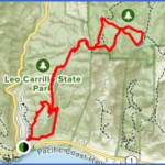
This Loop Hike In Leo Carrillo State Park Leads To Ocean Vista, A 612-Foot Bald Knoll With Great Views Of The Malibu Coastline And Point Dume. The Willow Creek Trail Traverses The East-Facing Hillside Up V-Shaped Willow Creek Canyon To Ocean Vista At The North End Of The Loop. En Route To The Overlook, The Trail Leads Through Native Grasslands And Coastal Sage Scrub. The Hike Returns Along The Nicholas Flat Trail, One Of The Few Trails Connecting The Interior Santa Monica Mountains To The Pacific Ocean.
To The Trailhead
From Santa Monica, Drive 26 Miles Northbound On The Pacific Coast Highway/Highway 1 To The Posted Leo Carrillo State Beach Entrance And Turn Right. (The State Park Is 14 Miles West Of Malibu Canyon Road And 8 Miles West Of Kanan Dume Road.) Park In The Day-Use Parking Lot. A Parking Fee Is Required.
From The Pacific Coast Highway/Highway 1 And Las Posas Road In Southeast Oxnard, Drive 11.1 Miles Southbound On The Pch To The Posted Leo Carrillo State Beach Entrance And Turn Left. Park In The Day-Use Parking Lot. A Parking Fee Is Required.
The Hike
The Trailhead Is 50 Yards Outside The Park Entrance Station At The Posted Camp 13 Trail On The Left. Walk 50 Yards On The Footpath To The Information Kiosk And Junction. The Loop Begins At This Junction. Take The Right Fork The Willow Creek Trail Up The Hillside And Parallel To The Ocean, Heading East. At A Half Mile The Trail Curves North, Traversing The Hillside While Overlooking The Arroyo And Willow Creek. Three Switchbacks Lead Aggressively Up To A Saddle And A Signed Four-Way Junction With The Nicholas Flat Trail, Which Leads North To The Upper Reaches Of The Park (Hike 125). The Left Fork Leads A Quarter Mile To Ocean Vista. After Marveling At The Views, Return To The Four¬Way Junction And Take The Left (West) Fork. Head Downhill On The Lower End Of The Nicholas Flat Trail, Returning To The Trailhead Along The Grassy Slopes Above The Park Campground.
Nicholas Flat From The Coast
Leo Carrillo State Park
35000 W. Pacific Coast Hwy
Hiking Distance: 7.4 Miles Round Trip Hiking Time: 4 Hours Configuration: Out-And-Back With 2 Loops Elevation Gain: 1,700 Feet Difficulty: Moderate To Strenuous Exposure: Exposed Hills And Shady Forest Dogs: Not Allowed
Maps: U.S.G.S. Truinfo Pass Leo Carrillo State Beach Map Tom Harrison Maps: Zuma-Trancas Canyons Trail Map
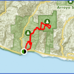
The Nicholas Flat Trail, Located Entirely Within Leo Carrillo State Park, Is A 3.8-Mile-Long Footpath That Connects The Interior Mountains With The Sea. The Trail Begins Near The Pacific Coast Highway At The South End Of The State Park And Climbs The Oceanfront Mountain To Nicholas Flat At The Upper (North) End Of The Park. The Flat Is A Large, Grassy Meadow Dotted With Oak Forests And Rock Outcrops. A Year-Round Pond Lies On The South End Of The Flat, With Mature Oaks And Picturesque Sandstone Rocks. From An Elevation Of 1,700 Feet, The Flat Offers Great Mountain And Coastal Views. The Trail Also Leads Past Ocean Vista (A 612-Foot Overlook At The Lower End Of The Park) And Vista Point (A 1,610-Foot Overlook At Nicholas Flat).
To The Trailhead
From Santa Monica, Drive 26 Miles Northbound On The Pacific Coast Highway/Highway 1 To The Posted Leo Carrillo State Beach Entrance And Turn Right. (The State Park Is 14 Miles West Of Malibu Canyon Road And 8 Miles West Of Kanan Dume Road.) Park In The Day-Use Parking Lot. A Parking Fee Is Required.
From The Pacific Coast Highway/Highway 1 And Las Posas Road In Southeast Oxnard, Drive 11.1 Miles Southbound On The Pch To The Posted Leo Carrillo State Beach Entrance And Turn Left. Park In The Day-Use Parking Lot. A Parking Fee Is Required.
The Hike
The Hike Begins 50 Yards Outside The Entrance Station At The Posted Camp 13 Trail On The Left. Walk 50 Yards On The Footpath To The Information Kiosk And Junction. The Willow Creek Trail Curves Around The Hill To The Right, Our Return Route. Begin On The Nicholas Flat Trail To The Left. Follow The East Canyon Slope Above The Campground While Ascending Through Coastal Scrub.
At One Mile, And Over 500 Feet In Elevation, Is A Saddle And Posted 4-Way Junction On A Ridge Overlooking Arroyo Sequit Canyon And Willow Creek Canyon. The Trail Straight Ahead The Willow Creek Trail Is The Return Route. To The Right, The Ocean Vista Trail Climbs A Short Distance To The 612- Foot Oceanfront Knoll With 360-Degree Panoramas.
Back At The 4-Way Junction, Continue North On The Nicholas Flat Trail. Follow The Ridge Inland, With Continuous Views Into Both Canyons And Across The Ocean To The Channel Islands. At 2.2 Miles, Wind Through Tall, Lush Foliage In A Shaded Canopy To An Unsigned Junction. Detour 100 Yards To The Right To A 1,737-Foot Knoll With Spectacular Views Of The Santa Monica Range And The Pacific Ocean. On The Main Trail, Continue About 60 Yards And Veer Right At A Trail Sign To A Junction With The Ridgeline Trail At 2.7 Miles.
Begin The Loop And Continue Straight. A Trail On The Right Leads To Another Overlook. Curve Left Around A Vernal Pool And Drop Into Nicholas Flat, A Large Grassy Plateau Dotted With Oaks And Surrounded By Rolling Hills. At 3.1 Miles Is A Junction With The Meadow Trail To The Left. Bear Right And Walk 25 Yards To A Y-Fork. Veer Right To The Pond. A Side Path To The Right Circles The Pond To A Grove Of Stately Oaks And A Beautiful Rock Formation. Continue On The Main Trail, Walking Through The Meadow On The Northwest Side Of The Pond To A Junction. The Trail Straight Ahead Leads To The Trailhead At The End Of Decker School Road (Hike 126). Take The Left Fork And Complete The Loop At The Junction With The Meadow Trail. Walk Straight Ahead On The Meadow Trail To A T-Junction With The Ridgeline Trail At 4.1 Miles. The Right Fork Leads To The Malibu Springs Trail. Bear Left And Weave Through The Forest To Vista Point, Overlooking Nicholas Flat. Continue To A Junction With The Nicholas Flat Trail, Completing The Double Loop At 4.7 Miles.
Retrace Your Steps 1.7 Miles (Back Towards The Ocean) To The Junction With The Willow Creek Trail At The Lower End Of The Park. Take The Willow Creek Trail To The Left. Descend On The West Wall Of Secluded Willow Creek Canyon. Steadily Loose Elevation Down Three Switchbacks. At The Mouth Of The Canyon Curve Right. Parallel The Pacific Coast Highway, Where There Is A Great View Of Leo Carrillo State Beach. The 0.9-Mile Willow Creek Trail Ends At The Trailhead Kiosk.
Maybe You Like Them Too
- Top 10 Islands You Can Buy
- Top 10 Underrated Asian Cities 2023
- Top 10 Reasons Upsizing Will Be a Huge Travel Trend
- Top 10 Scuba Diving Destinations
- World’s 10 Best Places To Visit

