Province: Norrbottens Ian. Region: Norrbotten. Altitude: sea level. Population: 68,000.
Postal code: S-95 Telephonecode: 09 20. Turistbyra,
Storgatan 35,
S-95131 Lule ; tel. 9 30 00.
HOTELS. SAS Globetrotter, 343 SP; Stadshotel-let, Storgatan 1 5, 2.00 Savoy, Storgatan 59,149 Esso Motor Hotel, Mjollkudden, 331 SP.
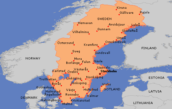
The Swedish port of Luled, at the N end of the Gulf of Bothnia, is the largest town in Norrbotten, the see of a bishop and the seat of the regional governor. It is also the gateway to the mountains of Lapland and the tundras of its northern
regions. The offshore islets and skerries, more than 300 in number, are noted for their animal and plant life. Although LuleS is only 110 km (70 miles) from the Arctic Circle the climate is mild: the average annual temperature is only 2 °C (3-5 °F) lower than at Malmo in southern Sweden, and in July LuleS has the highest number of sunshine hours in Sweden (300310). During the summer, LuleS ranks with Narvik as one of the two principal ports for the shipment of the iron ore transported from Gallivare and Kiruna on the Lapland railway. LuleS harbour is usually frozen over until May.
Old warehouses on the quay, LuleS was founded by Gustavus Adolphus in 1 621 and moved in 1 649 to its present site on a promontory in the Lulealv. Most of the town’s old houses have been destroyed by fire. LuleS was slow to develop, and by 1940 had a population of only 1 4,000. A state-owned ironworks (Norrbottens Jarnverk AS) was built on the island of Svarto and, within ten years, the population had doubled. It continues to grow.
SIGHTS. In the middle of the old town stand the new Cathedral (1887-93) and the ten-storey Town Hall (1 957). To the E, in Storgatan, the main business street of the town, is a modern shopping complex. At the W end of Storgatan lies Herme-linspark. On the southern outskirts ofthe town is the Norrbotten Museum (interesting collection illustrating Lapp customs and traditions) and to the W of the Museum are the Provincial Government Offices (Lansresidens). To the NW is the promontory of Gultzauudde, with a good bathing beach, tennis courts and other sports facilities, and restaurants. Open-air performances are given here on Thursdays during the summer.
SURROUNDINGS. 10 km (6 miles) W, on the original site of the town, is Kyrkstaden, the church town a settlement of little wooden houses designed to provide overnight accommodation for a congregation which had to travel long distances to attend church. With almost 500 church huts (kyrkstugor) this is the largest church town in Sweden. The church itself dates from the early 14th it is richly decorated and has an altar (1 520) from Antwerp. 40 km (25 miles) NW of LuleS in the valley of the Lulealv is Boden (pop. 28,000; Bodensia Hotel, 95 b.), a garrison town and railway junction where the LuleS-Gallivare mineral railway meets the N-S line. The rather military atmosphere of the town has a long tradition. The fortress built here in 1901 was almost entirely blasted out of the rock. There is also an Army Museum.
80 km (50 miles) NE of LuleS, at the mouth of the Kalixalv, is Kalix (Valhall Hotel, 95 b.), which reflects a combination of old peasant traditions with the early development of industry. The church (1472) has a late medieval reredos, a fine font and a modern altar window (Par Andersson). On the road to Lapptrask, to the N, is the EnglundsgSrd (typical 1 9th c. peasant interior). The Kalix Museum is in the offices of the commune. A view of the way of life of the wealthier classes at the end of the 1 9th c. is provided by the manor-houses of Bjorknas, Filipsborg and Grytnas, at the mouth of the Kalixalv. Some 10 km (6 miles) beyond Kalix a restricted area extends to the Arctic Circle: there are limitations on traffic through the area, and camping is prohibited.
58 km (36 miles) SW of LuleS is PiteS (pop. 1 0,000; Cristofer Hotel, 52 Stads hotel let, 73 b.), a port and industrial town at the mouth of the Pitealv. The town was originally founded by Gustavus Adolphus in 1 621 on the site now occupied by Ojebyn, but in 1 666 it was moved 6 km (4 miles) to the mouth of the river. The 15th c. church at Ojebyn is surrounded by 17th c. kyrkstugor (see above). The wooden church in PiteS dates trom 1648 (restored 1 950-1); its pulpit (1702) is similar to those of the Gammelstad and Ojebyn churches. Most of the town’s old timber houses are to be found in the vicinity of the market square (mid-1 9th c. Town Hall). 6 km (4 miles) SE, on Pitholmen, is Havsbaden, a beach 10 km (6 miles) long.
Lulea Sweden Map Photo Gallery
Maybe You Like Them Too
- The Best Cities To Visit in The World
- World’s 10 Best Places To Visit
- Coolest Countries in the World to Visit
- Travel to Santorini, Greece
- Map of Barbados – Holiday in Barbados

